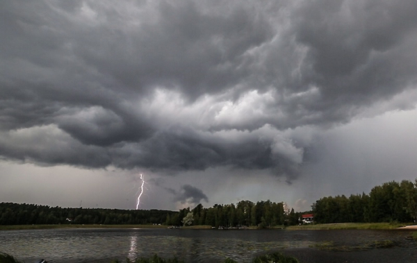

Lightning strikes in Nenäinniemi, Jyväskylä. Photo: Harri Kiiskinen / Str / Lehtikuva
- Next Article Helsinki diplomacy summit opens with divided voices on peace and war
Heavy thunderstorms are expected to sweep across Finland on Thursday, bringing high winds and sudden rainfalls to already overheated regions. The Finnish Meteorological Institute (FMI) has issued orange and yellow warnings for large parts of southern and central Finland.
According to Jani Sorsa, a duty meteorologist at the FMI, the most intense gusts could momentarily exceed 25 metres per second. These wind speeds are comparable to storm conditions and fall under the orange warning category, which signals hazardous weather. Yellow warnings indicate potentially dangerous weather, with wind gusts likely to exceed 15 metres per second.
Thunderstorms are forecast to develop during the afternoon and evening. The storms may disrupt electricity supply and cause minor flooding, particularly in urban areas where drains struggle with sudden downpours.
Short but intense rain showers are also likely in southern parts of the country throughout the afternoon. The FMI has issued a separate yellow warning for heavy rain in these regions.
Sorsa said the greatest potential for intense rainfall is in the south, while the risk of powerful wind gusts increases further north in central Finland.
Temperatures remain high across the country. A heat warning remains in place for nearly all of Finland except the northernmost parts of Lapland. Most of the warnings issued are in the orange category, indicating dangerous heat levels. Only a few southern areas have been placed under the yellow warning level.
The heatwave showed no sign of weakening on Thursday. By late morning, the temperature had reached 31.3°C in Kosulanniemi, Varkaus, and 30.5°C in Tuhkakylä, Sotkamo. It marked the 20th consecutive day that temperatures have exceeded 30°C somewhere in Finland, extending a national record.
While the incoming thunderstorms may offer temporary relief from the heat, the underlying weather pattern remains unchanged. Sorsa noted that temperatures can drop rapidly, even by as much as ten degrees, when thunderclouds pass through an area.
FMI meteorologists continue to monitor the development of the storm cells closely. The public is advised to secure loose items outdoors, avoid unnecessary travel during severe weather alerts, and follow real-time updates on official channels.
HT
- Next Article Helsinki diplomacy summit opens with divided voices on peace and war
Source: www.helsinkitimes.fi